can you find your way?
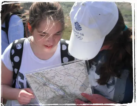
Once equipped with the necessary map reading skills from our tutors, students will put their navigational skills to the test and manoeuvre from point to point in a race against the clock.
Our moorland and woodland orienteering courses are designed so that there are natural boundaries and strategic points for staff to be positioned around the course, allowing students to work more independently and develop real life decision making and problem-solving skills.
Our orienteering courses are run in the Yorkshire Dales and North York Moors National Parks, and the level of difficulty of the course and its challenges are adapted to the age and level of experience of students on adventure.
What’s Included
Students are provided with the following equipment, as and when appropriate.

All specialist equipment
Maps.
All specialist clothing
Waterproofs and wellies when required. Ideally students should bring their own wellies, but we have plenty on hand to lend.
Transport
Once at the centre, all transport to and from adventure activities is provided.
Experienced, full-time, outdoor teachers and tutors
Each group of 12 students is led by a fully qualified and experienced outdoor tutor.
– back in the classroom –
curriculum links
Orienteering can not only hit various parts of the PE and Citizenship curriculum but can be an exciting and adventurous way to develop knowledge in other areas of the curriculum such as maths by using scales, ratios and geometry or learning how to understand maps and use them practically.
Key Stage 2
Maths: Geometry
In orienteering, students can develop their geometry knowledge through navigating and mapwork. Lines of symmetry can be identified and used as handrail features, and the advantages of the orientation of the map can be explored. Routes can be described to show knowledge of how movements will be made around the marker positions.
Geography: Map reading
Students can be introduced to orienteering maps, their key features, scales, and uses. They will then be taught how to start using these as an important tool in navigation and identifying the surrounding area to them.
Art: Map drawing
Students can survey the area and then draw their own maps to represent it. Then, using the drawn map, use it to navigate around a set course.
Key Stage 3
Geography: Maps
Students can be introduced to orienteering maps, their key features, scales, and uses. They will then be taught how to start using these as an important tool in navigation and identifying the surrounding area to them.
Maths: Ratio and proportions
Scales can be used from the maps to measure the distance of the course to be completed. Times can then be estimated based on speed. The legs of the course can be broken down into sections, and ratios applied to the times or distance of each leg.
Key Stage 4
Geography
Taking orienteering to the next level, students will work in a more open and mountainous environment. They will learn to read contour lines and what has created and shaped the land, whilst searching for markers in a more competitive setting.
P.E.
Orienteering can be a competitive sport and students will have the opportunity to learn how to take part in a team, and as individuals, using tactics, map knowledge, and learning to pace themselves to complete the course.
LOCATIONS: Offered at both Bewerley Park and East Barnby
YEAR GROUPS: Suitable for Primary School, Secondary School, and post 16 students

DURATION: Available as a full or half day activity

DIFFICULTY: Adapted to the age and level of experience of students on adventure
MIN GROUP SIZE: 12 Students
can you find your way?
Once equipped with the necessary map reading skills from our tutors, students will put their navigational skills to the test and manoeuvre from point to point in a race against the clock.
Our moorland and woodland orienteering courses are designed so that there are natural boundaries and strategic points for staff to be positioned around the course, allowing students to work more independently and develop real life decision making and problem-solving skills.
Our orienteering courses are run in the Yorkshire Dales and North York Moors National Parks, and the level of difficulty of the course and its challenges are adapted to the age and level of experience of students on adventure.
What’s Included?
Maps
All specialist clothing
Waterproofs and wellies when required. Ideally students should bring their own wellies, but we have plenty on hand to lend.
Transport
Once at the centre, all transport to and from adventure activities is provided.
Experienced, full-time, outdoor teachers and tutors
Each group of 12 students is led by a fully qualified and experienced outdoor tutor.
classroom benefits
curriculum links
Orienteering can not only hit various parts of the PE and Citizenship curriculum but can be an exciting and adventurous way to develop knowledge in other areas of the curriculum such as maths by using scales, ratios and geometry or learning how to understand maps and use them practically.
Key Stage 2
Maths: Geometry
In orienteering, students can develop their geometry knowledge through navigating and mapwork. Lines of symmetry can be identified and be used as handrail features, and advantages of orientation of the map can be explored. Routes can be described to show knowledge of how movements will be made around the marker positions.
Geography: Map reading
Students can be introduced to orienteering maps, their key features, scales, and uses. They will then be taught how to start use these as an important tool in navigation and identifying the surrounding area to them.
Art: Map drawing
Students can survey the area and then draw their own maps to represent it. Then, using the drawn map, use it to navigate around a set course.
Key Stage 3
Geography: Maps
Students can be introduced to orienteering maps, their key features, scales, and uses. They will then be taught how to start using these as an important tool in navigation and identifying the surrounding area to them.
Maths: Ratio and proportions
Scales can be used from the maps to measure the distance of the course to be completed. Times can then be estimated based on speed. The legs of the course can be broken down into sections, and ratios applied to the times or distance of each leg.
Key Stage 4
Geography
Taking orienteering to the next level, students will work in a more open and mountainous environment. They will learn to read contour lines and what has created and shaped the land, whilst search for markers in a more competitive setting.
P.E.
Orienteering can be a competitive sport and students will have opportunity to learn how to take part in a team, and as individuals, using tactics, map knowledge, and learning to pace themselves to complete the course.